
Social Sector Use Cases
Explore how SLA's geospatial tools — from wheelchair-friendly routing to student-led innovations — are making Singapore more inclusive and accessible for all.
Last updated on 3 August 2026
SLA Barrier-free Access (BFA) Routing
Developed by the Singapore Land Authority (SLA), Barrier-Free Access (BFA) Routing provides wheelchair-friendly routes that have been tested and verified by wheelchair users. These routes guide users to safe, accessible paths, as not all routes accommodate wheelchair users.
What Does BFA Routing Do?
BFA Routing highlight routes that are more suitable for wheelchair users by avoiding common physical barriers such as stairs, steep gradients, and inaccessible walkways. By reducing uncertainty, it supports safer, more independent movement through the city.
Where Is It Available?
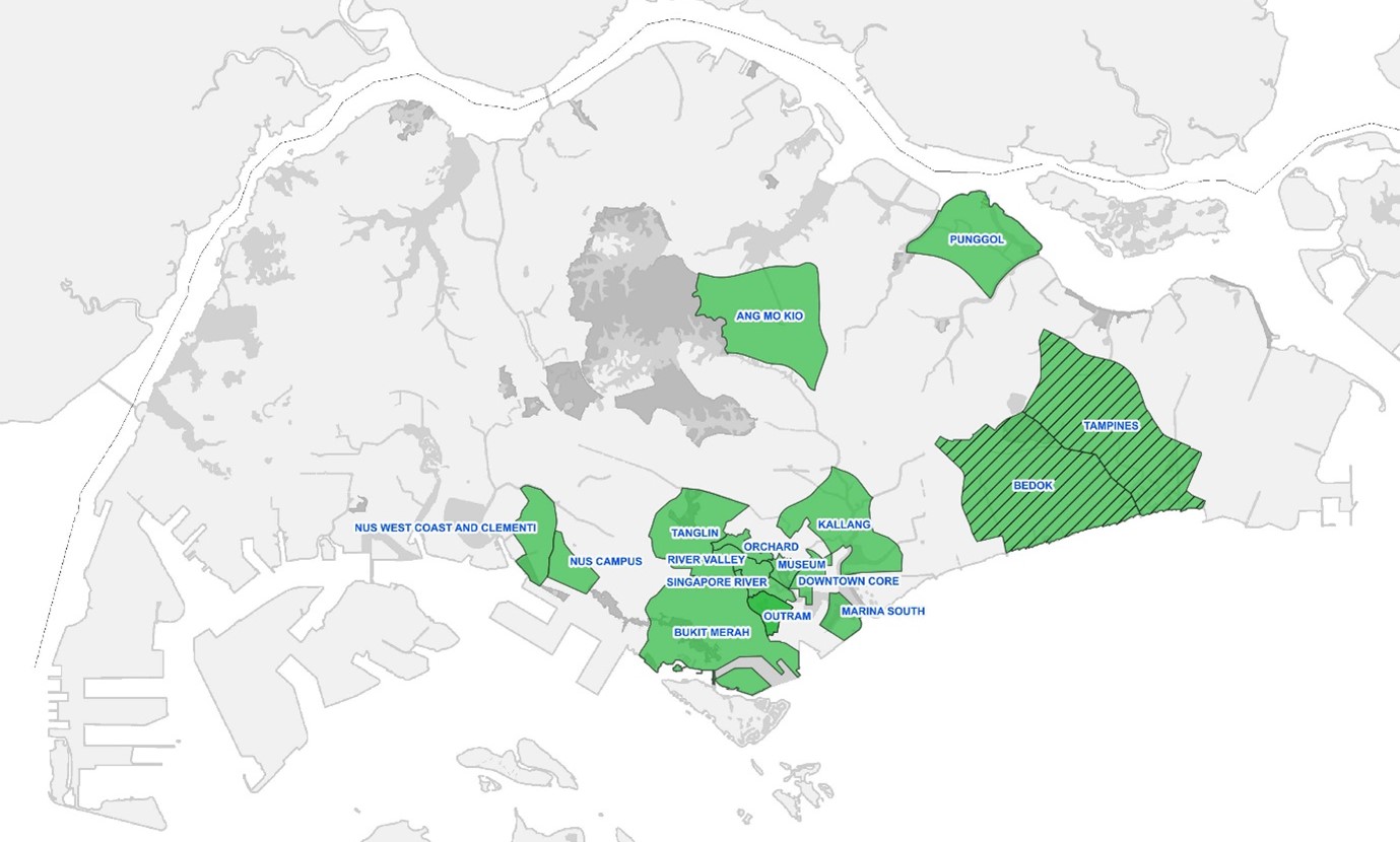
BFA routing is currently available in selected areas across Singapore, including:
Punggol, Ang Mo Kio, Kallang, Marina South, the Museum area, parts of the Downtown Core, Bukit Merah, River Valley, NUS Campus, West Coast & Clementi, Tanglin, Orchard, and Outram.
The Bedok and Tampines areas are expected to be ready by early March 2026. Coverage will continue to expand as more routes are tested and verified.
How we can use Barrier Free Routing:
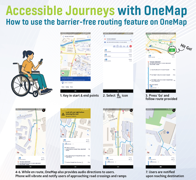
Accessibility is not one-size-fits-all. SLA’s Barrier-Free Access Routing transform lived experience into shared knowledge, making movement through Singapore more predictable, empowering, and inclusive. Each verified route brings us closer to a city where everyone can navigate with dignity and confidence.
For any enquiries, please write to: https://go.gov.sg/bfa-enquiries (opens in new tab)
Directory of Family Services
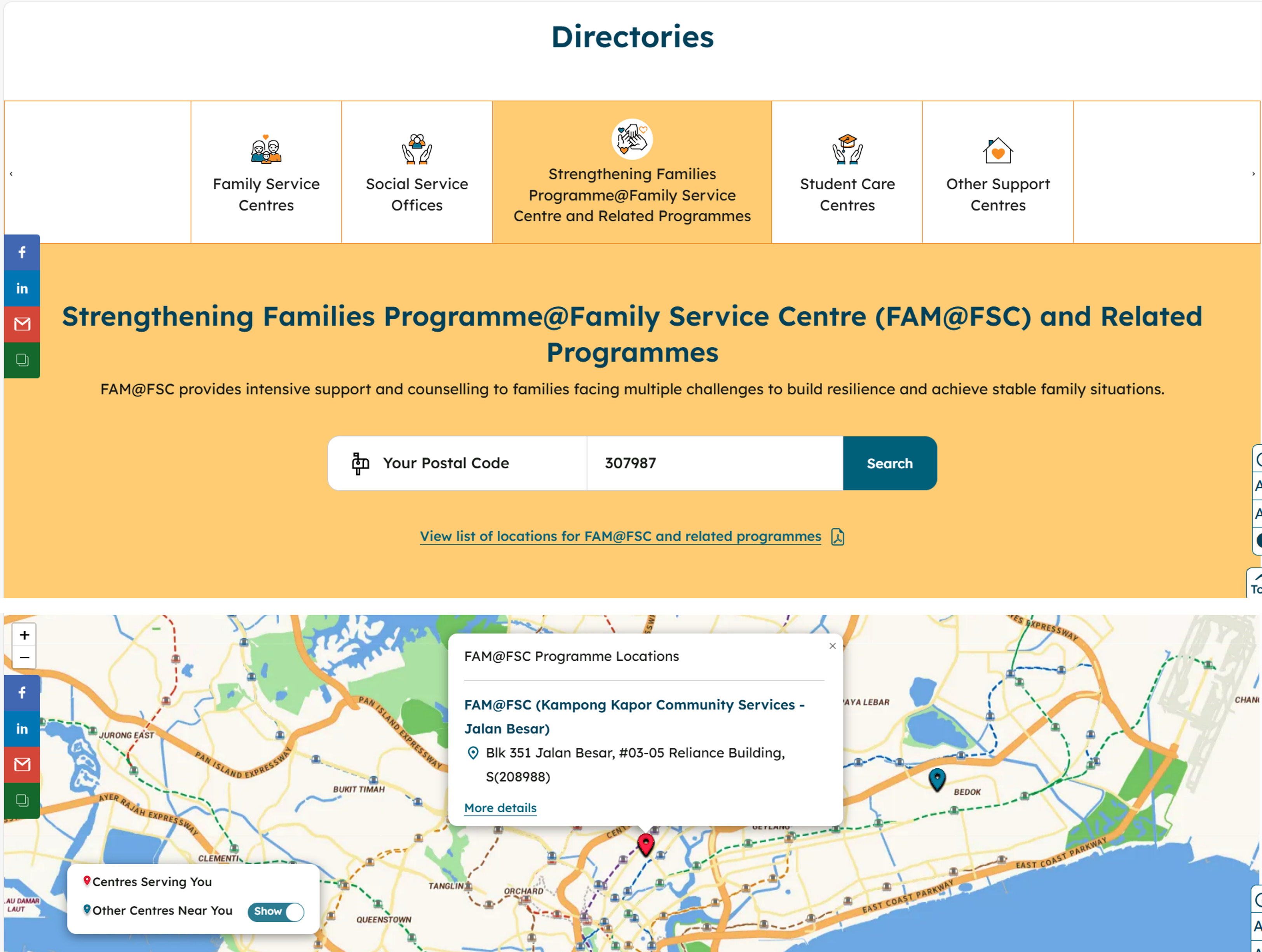
The Directory of Family Services (DFS) is a database maintained by the Ministry of Social and Family Development (MSF) that contains information about social services and programmes available in Singapore. It serves as a comprehensive resource for social service professionals and the public to locate and access various family-related support services.
The DFS includes details about:
Family Service Centres (FSCs)
Social Service Offices (SSOs)
Student Care Centres
Other social service organisations and their programmes
Social service professionals use this directory to make appropriate referrals for their clients, while members of the public can use it to find nearby services that meet their needs.
Amazon Web Services-SLA Geospatial Innovation Challenge 2025
Student Projects Applying Geospatial to Socio-Healthcare Challenges
Held in conjunction with GeoEngage 2025, the AWS–SLA Geospatial Innovation Challenge 2025 invited students from Singapore’s IHLs to reimagine how OneMap and geospatial insights could address real-world socio-healthcare issues.
These student projects demonstrate how geospatial technologies can be harnessed to build stronger, healthier, and more inclusive communities.
1. ReMind: Supporting Dementia & Community-Assisted Eldercare (Nanyang Technological University)
With dementia cases in Singapore projected to increase from 82,000 today to 152,000 by 2030, ReMind applies geospatial technology to enhance safety and caregiving for persons living with dementia.
The team developed a mobile app that uses OneMap’s geospatial data for real-time tracking and routing of seniors who may wander from their safe zones.
• Caregiver Support: Alerts notify caregivers when individuals move beyond designated areas and guide them via the fastest route to locate them.
• Community Response: Similar to SCDF’s myResponder app, ReMind mobilises nearby community responders to locate and share sightings of missing persons, guiding them to Dementia Go-to Points on OneMap and forming a community-centric safety network.
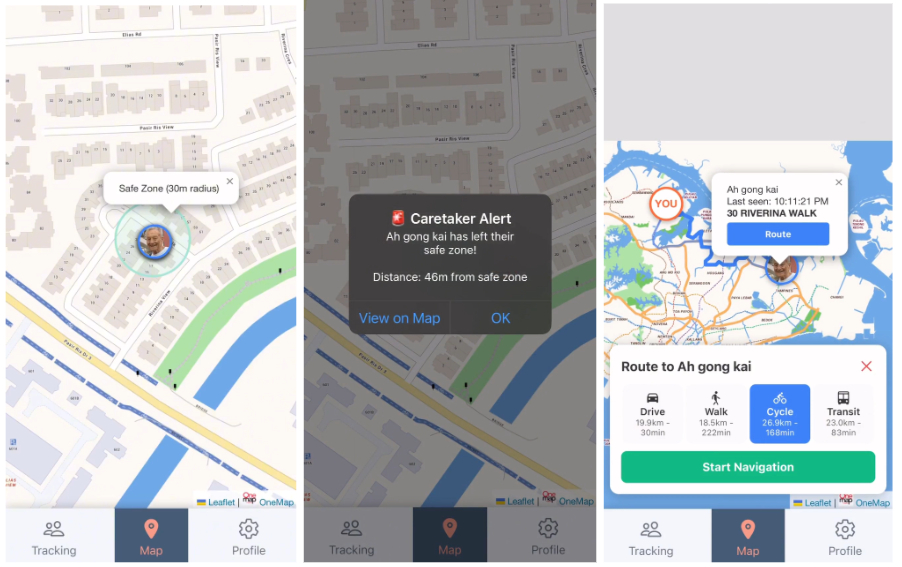
Real-time tracking, alert notification, and routing capabilities
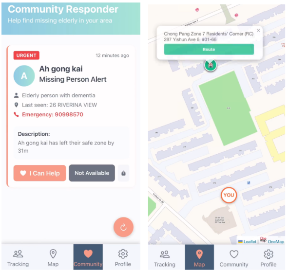
Community responder function
The project has attracted the interest of DementiaSG, which is exploring potential integration with its national Cara platform to strengthen dementia-friendly navigation and support.
2. VapeWatch: Geospatial Insights to Identify and Respond to Emerging Vaping Hotspots (Singapore Management University)
With vaping cases rising to 2,500 in just the first half of 2025, VapeWatch demonstrates how geospatial intelligence can be used to strengthen public health surveillance, enforcement, and youth outreach.
The team designed VapeWatch as a connected ecosystem linking citizens, enforcement agencies, outreach workers, and community partners through a shared geospatial data platform.
Detection: Citizens can submit anonymous vaping incident reports through a mobile app, verified by AI-based photo recognition to improve reliability.
Enforcement: Officers access an operational dashboard with incident maps, temporal pattern analysis, and AI-generated patrol recommendations, to identify hotspots and optimise resource deployment.
Education & Outreach: Volunteers and community organisations can use a community dashboard that visualises hotspots, neighbourhood risk levels, and intervention priorities to focus preventive programmes.
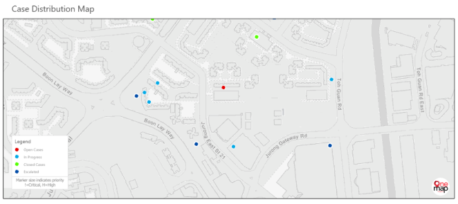
Mapping of vaping cases
In the future, VapeWatch can be developed into a broader Youth Risk Geospatial Intelligence Platform, capable of supporting early intervention and predictive analytics for issues such as mental health crises, educational support, and youth development.
3. CareLink: Targeted Aid Distribution & Outreach for Vulnerable Communities (Singapore Institute of Management – University at Buffalo)
In 2024, Singapore generated 784,000 tonnes of food waste, even as some households continued to experience food insecurity. CareLink bridges this gap through OneMap that links local mini-marts and shops with residents in need, especially among elderly residents and low-income families.
• Mapping Supply and Demand: Merchants can list surplus or near-expiry food items on OneMap, while nearby residents can view and request items available in their vicinity.
• Targeted Aid Delivery: The system visualises areas of higher food insecurity, enabling community organisations to plan more efficient and equitable outreach.
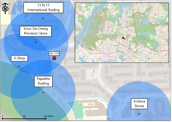
Mapping of beneficiaries to nearby food items
By combining sustainability and social support, CareLink turns waste reduction into a community-driven aid network, using geospatial intelligence to match surplus to need.
4. Purposeful Event: Gamifying Wellness for Active Ageing (Institute of Technical Education)
As Singapore’s population ages, Purposeful Event encourages seniors to remain socially and physically active by connecting them to nearby community activities through a gamified OneMap interface.
• Discover & Connect: Seniors can browse wellness and social events around them, view directions on OneMap, and receive reminders of upcoming activities.
• Motivate Participation: The app incorporates a reward-based gamification system, allowing users to earn points for attending events and redeem small prizes, fostering a sense of achievement and engagement.
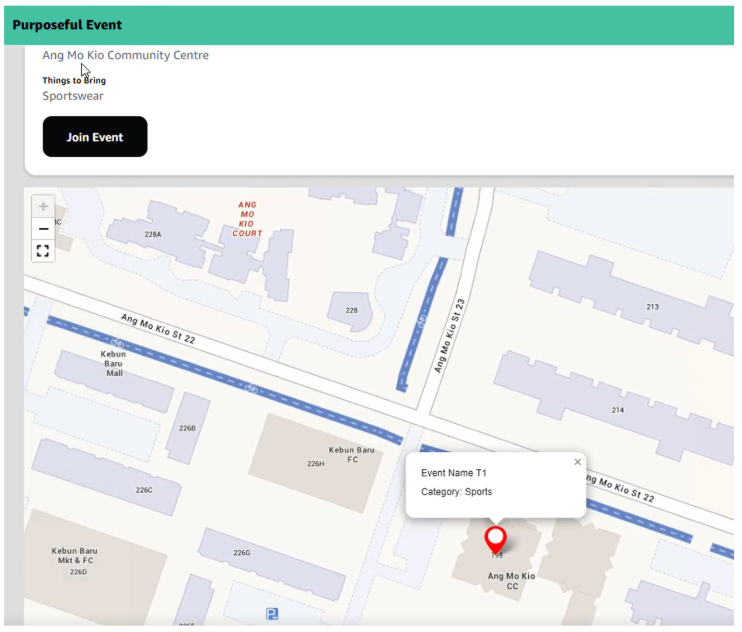
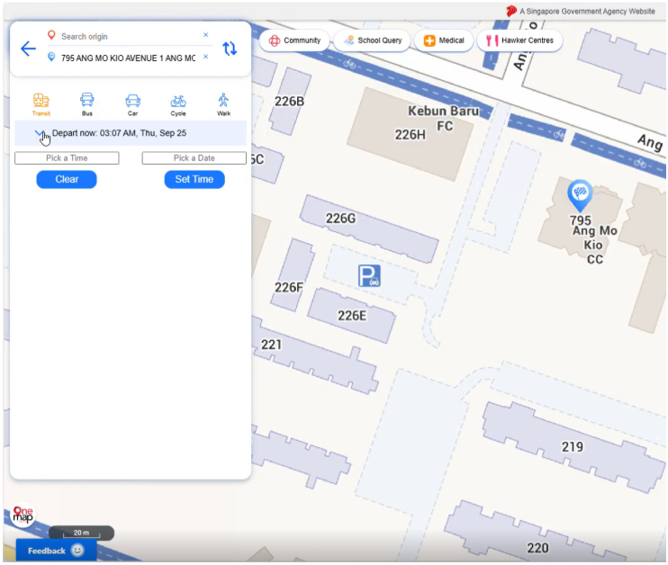
Map of community activities and routing capabilities
By blending geospatial mapping with behavioural design, Purposeful Event helps create more connected, active, and inclusive communities for seniors.
Advancing Geospatial for Social Good
These student projects highlight how geospatial data and technology can enhance social and health outcomes, from dementia care and youth wellbeing, to addressing social vulnerability and active ageing. Through future socio-healthcare editions of GeoEngage and continued collaboration with sector agencies and partners, SLA aims to deepen geospatial innovation and partnerships that strengthen Singapore’s community and care ecosystem.